Usk Riverside Path: Linking Newport's Bridges, Parks and Quays on Foot
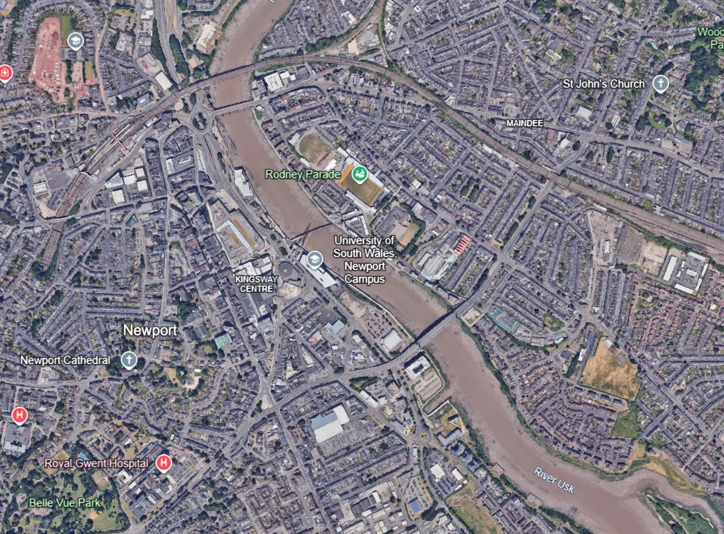
On a bright morning, the River Usk glides past Newport's bridges with the tide pulling hard at its muddy banks, and a steady stream of walkers, runners and cyclists follows the water. The Usk riverside path is not one single scheme. It is a chain of linked routes that has grown up along the banks, and it now connects the city centre, its green spaces and historic Caerleon.
A River Path with Many Parts
The River Usk has shaped Newport for centuries, bringing trade, industry and the crossings that give the city its character. For much of the modern era the banks were more working edge than public space. Today the same frontage has become one of the city's most useful routes for everyday walking and cycling.
The path forms part of a wider network. The best-known stretch is the Newport to Caerleon section of National Cycle Route 88, which follows the river and is largely traffic-free. Alongside it sit the Wales Coast Path through the city and the start of the long-distance Usk Valley Walk, so one riverbank serves local commuters and visiting hikers alike.
Newport to Caerleon: The Core Route
The Newport to Caerleon route is generally described as about 3.7 miles (6km) each way. It is mostly flat, which makes it popular with families, and a large share of it is traffic-free. Some descriptions quote a seven-mile figure for the full riverside link, so check the signs and a current map before setting out.
The route begins in the city centre, near the railway station, and heads north beside the Usk. It passes beneath the M4 flyover, then climbs briefly to a bend where the river views open up. For a short stretch it moves away from the water along Pillmawr Road, then rejoins the riverbank for the final approach to Caerleon.
Boardwalks and Floodplain
Because the land beside the Usk is low-lying and the river is tidal, part of the route crosses floodplain. A boardwalk made from recycled material was built there so the path stays usable at high tide. It is a practical piece of engineering that also gives walkers a close view of reeds, mudflats and birdlife.
Arriving in Caerleon
The route ends in Caerleon, once the Roman fortress of Isca. The footbridge beside the old road bridge was opened in 1968, because the road bridge was too narrow for pavements and had been hazardous for pedestrians. Roman remains, the museum and the village's pubs are all within a short stroll of the river.
The City Centre Loop: Bridges and the Waterfront
Those who want something shorter can follow a circular route of about 5.6km that uses both banks of the central stretch. It starts at Newport Bridge, passes George Street Bridge and the area known as Monkey Island, then crosses City Bridge and returns along the opposite bank. It is gently graded and takes roughly an hour to an hour and a half at an easy pace.
Along the way, the route shows how different each crossing looks. Newport Bridge is the older, more traditional crossing. George Street Bridge, with its distinctive profile, is an unmistakable part of the skyline. City Bridge is the newest of the three. Together they make the Newport waterfront a good place to see how the city has changed over time.
Connections Beyond the City
The riverside path also works as a gateway to longer journeys.
- Usk Valley Walk: this waymarked trail of about 48 miles starts at Caerleon and follows the valley north to Brecon.
- Monmouthshire and Brecon Canal: a mainly traffic-free route links Newport with the canal basin at Pontymoile, using the riverbank before joining the towpath.
- Wales Coast Path: the City to Sea route, opened in May 2012, links the city centre riverfront with the nature reserve and estuary to the south.
- Route 88 westwards: another section starts near Tredegar House and runs across the Wentloog Levels towards Marshfield and Cardiff.
Newport Wetlands and the Severn Estuary lie further downstream, and the Newport Transporter Bridge is another landmark on the river that visitors often add to their day.
Why It Matters for Newport Regeneration
The path plays a quiet but real part in Newport regeneration. It links university campuses, the railway station and several schools with the city centre, giving people a safe alternative to busy roads. It also puts the riverside redevelopment, from new student buildings to leisure and arts venues, within easy reach of the wider network of green space.
For a city proud of its heritage, the path also allows people to read the landscape. Roman Caerleon, Victorian engineering, twentieth-century industry and modern regeneration all sit within a few miles of one another, and the River Usk ties them together.
Tips for Using the Path
- Wear sturdy shoes, as some stretches are unsealed and can be muddy after rain.
- Share the path courteously, as walkers, runners and cyclists all use it.
- Check tide times if you want to see the Usk at its most dramatic, as its large tidal range changes the view hour by hour.
- Travel by train to Newport station and walk to the start, which makes a car-free day out easy.
A Path Worth Following
The Usk riverside path shows what a city can do with its natural frontage: reconnect it, make it accessible and let people enjoy it. Whether you walk a short city centre loop or the full route to Caerleon, you are following the water that made Newport. It is a fitting way to see the city's bridges, green spaces and quays together, on foot.